
Mt Nebo
Revision Date: April 12, 2026
Mt. Nebo State Park offers a sweeping view of the Arkansas River Valley. The Park's Visitor Center is located on top of Mt Nebo 7 miles west of Dardanelle, Arkansas, on Hwy 155.
It was first flown by Roy Mahoney in July 5, 1975 (over 45 years ago). Roy's brother, Bruce, made this 8mm video of this historic event. Roy added these notes of his flight,
Flipped coin - I won (?) against Gene Hobson, tail wind 5mph, landing area 4 to 1. Lost altitude getting airspeed on take off. Flew straight for field. Started hearing crickets (probably cicadas) in woods below (meaning trees were getting nearer). At 50' spotted a thin low area in the trees, 180'd back to it. Flared over trees, crashing thru - hung up 5' off ground. Got a 2" rip in the sail. ...Couple others broke down their gliders after watching me get swallowed by trees.
General notes:
A minimum USHPA pilot rating of H3 or P3 is required by the State of Arkansas to fly this site. H3 and P3 pilots must be accompanied by an advanced pilot (H4 or P4 respectively) until they have successfully flown this site a minimum of 10 separate flights along with a minimum of 5 hours flight time.
The state of Arkansas requires all pilots to have a $1,000,000 liability policy. Your default liability policy limit from USHPA is only $500,000. Contact USHPA in order to have this the higher limit ($1,000,000) for additional cost.
Sink cycles can be severe in midday thermal conditions.
Good foot launch skills are required. If you have any doubts of your skills, contact an USHPA instructor. We have lost many sites across the Unites States because of irresponsible pilots and other AH's who think they know how to fly ultralights safely. If you see someone flying in an irresponble manner contact an USHPA instructor, a BMF officer, or a State Park ranger.
Usually evenings are the best time to fly for pilots unfamiliar with the site or for lower performing gliders.
All pilots need to be aware of environmental factors such as thunderstorms suddenly popping up, hazardous winds in the evening, and other weather hazards common to the central U.S.
Please contact us if you need a site guide and we will be happy to help.
When pilots arrive at the Park:
- Before the first flight of each year: complete the registration and release forms at the Visitor Center. Proof of current USHPA membership, insurance, rating, and photo ID are required.
- Daily sign-in at the Visitor Center is required.
- Tandem flights: passengers must also register with the Park.
Mt. Nebo has 3 launch areas and 6 landing zones
East South NE (Visitor Center)
East LZ Race Track LZ Vernon LZ Florida LZ Ware LZ Wesley LZ
East launch
35.2140 -93.2510 Dardanelle, Arkansas
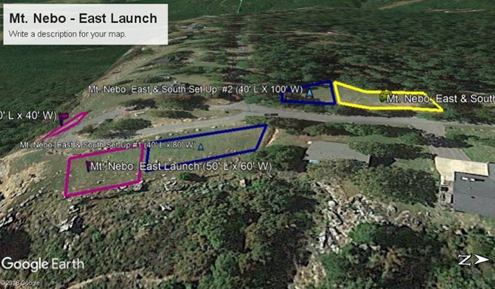
launch = magenta, glider setup = blue, parking = yellow
| Requirements for pilots | Paraglider | Hang Glider |
|---|---|---|
| Minimum required rating and special skills | P3 | H3 |
| Recommended wind limits (mph) | Min:3 | Min:3 |
| Ideal:6 | Ideal:7 | |
| Max:18 | Max:20 | |
| Gust:5 | Gust:5 | |
| Wind direction ideal | 85-95 | |
| Wind direction OK | 80-105 |
| Launch altitude ft | 1,740 |
|---|---|
| LZ altitude ft | 517 |
| Launch to LZ distance | 1.5 mi |
| Glide ratio to LZ | 6.5 |
East launch notes
Launch is an east facing slope located at the Park's Sunrise Point. Below the bluff line is a significant rock hazard that must be cleared immediately after launching. Pilots should launch with sufficient wind velocity and accelerated launch technique to clear this obstacle. This site is primarily a thermal flying site with opportunities for ridge soaring in predominantly east winds. The East Launch may be flown by tandem pilots only when the wind velocity is sufficient to allow launching before reaching the bluff line.
The East LZ is the primary landing zone. The Race Track LZ should be used for a bail-out in those instances when pilots cannot reach the East landing field. The Vernon LZ should only be used in an emergency.
PG
Be prepared to experience severe sink between launch and the LZ!
HG
[none]
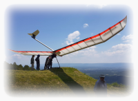
[photos of east launch]
South launch
35.2139 -93.2515 Dardanelle, Arkansas
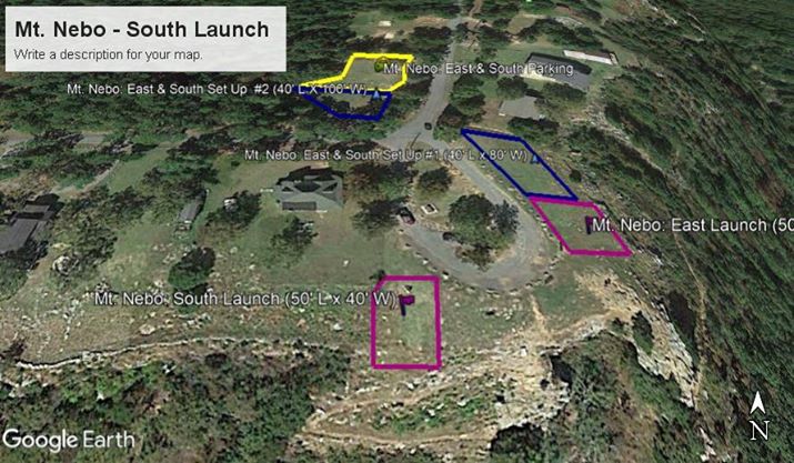
launch = magenta, glider setup = blue, parking = yellow
| Requirements for pilots | Paraglider | Hang Glider |
|---|---|---|
| Minimum required rating and special skills | P3 | H3 |
| Recommended wind limits (mph) | Min:3 | Min:3 |
| Ideal:6 | Ideal:10 | |
| Max:18 | Max:20 | |
| Gust:5 | Gust:5 | |
| Wind direction ideal | 160-210 | |
| Wind direction OK | n/a |
| Launch altitude ft | 1,735 |
|---|---|
| LZ altitude ft | 517 |
| Launch to LZ distance | 1.3 mi |
| Glide ratio to LZ | 5.7 |
Notes – South launch (HG only)
Launch is a south facing slope at the edge of a bluff located at the park's Sunrise Point. To reach the landing fields the pilot has to turn to the east immediately after launch unless ridge soaring. This site is primarily a thermal flying site with opportunities for ridge soaring in predominantly south winds. The site may be flown by tandem pilots only when the wind velocity is sufficient to allow launching before reaching the bluff line.
The primary landing zone is the East LZ. Alternate landing fields are Race Track LZ, Florida LZ, or, in case of an emergency, Vernon LZ.
PG
PG is not approved at South launch without an USHPA instructor's permission.
HG
[none]
[we need photos of South launch - please contact Britton Shaw if you can supply - thank you]
Northeast launch
35.2282 -93.2551 Dardanelle, Arkansas
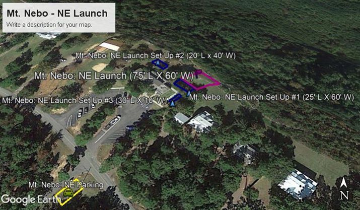
launch = magenta, glider setup = blue, parking = yellow
| Requirements for pilots | Paraglider | Hang Glider |
|---|---|---|
| Minimum required rating and special skills | P3 | H3 |
| Recommended wind limits (mph) | Min:3 | Min:3 |
| Ideal:6 | Ideal:10 | |
| Max:18 | Max:20 | |
| Gust:5 | Gust:5 | |
| Wind direction ideal | 30-60 | |
| Wind direction OK | n/a |
| Launch altitude ft | 1,703 |
|---|---|
| LZ altitude ft | 513 |
| Launch to LZ distance | 1.0 mi |
| Glide ratio to LZ | 4.4 |
Notes – Northeast launch
Launch is a slope followed by a drop off to a bowl at the top of a ravine and located directly behind the park's Visitor Center. Best launch windows for this site tend to be earlier in the day due to early shading of the easterly slope. Before launching the flag in the bowl must show air flow toward the launch. This site is primarily a thermal flying site with limited possibilities for ridge soaring in predominately northeast winds.
Landing zones are the Ware LZ and the Wesley LZ.
PG
During light conditions, the deep dip near the top of the launch slope may unload your glider.
HG
[none]
[we need photos of Northeast launch - please contact Britton Shaw if you can supply - thank you]
East LZ
35.2197 -93.2249 Dardanelle, Arkansas

| Launch altitude ft | 1,740 |
|---|---|
| LZ altitude ft | 517 |
| Launch to LZ distance | 1.5 mi |
| Glide ratio to LZ | 6.5 |
Notes – East LZ
The best approach in wind directions from east to south is to make the final approach to the south. There is a gentle up slope in the middle of the field. There are significant obstacles in the field to be avoided: trees, buildings, and horses. The horses are familiar with flight operations. Parking is limited along the side of the road and the gate entrance should not be blocked. Vehicles and spectators are not allowed in the landing field. There are occasions when this site produces significant sink cycles.
PG
[none]
HG
[none]
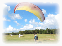
[photos of East LZ]
Race Track alternate LZ
35.2164 -93.2281 Dardanelle, Arkansas No power lines in the LZ
The Race Track landing field should be used for a bail-out in those instances when pilots cannot reach the East landing field.
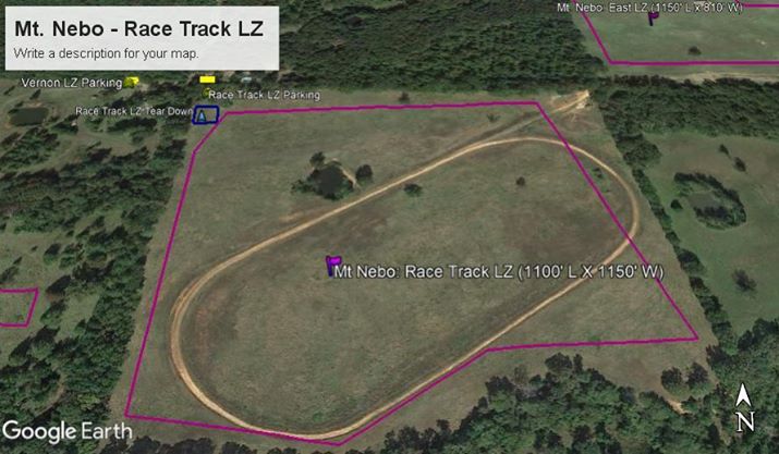
launch = magenta, glider setup = blue, parking = yellow
| Launch altitude ft | 1,740 |
|---|---|
| LZ altitude ft | 541 |
| Launch to LZ distance | 1.3 mi |
| Glide ratio to LZ | 5.7 |
Notes – Race Track alternate LZ
[none]
PG
[none]
HG
[none]
[we need photos of Race Track LZ]
Vernon field emergency LZ
35.2166 -93.2323 Dardanelle, Arkansas
In case of emergencies the Vernon landing field may be used.
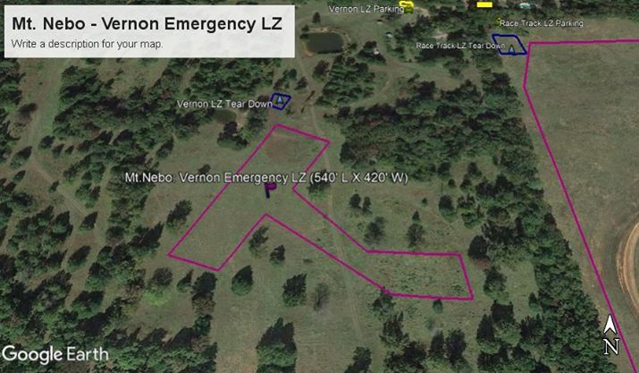
launch = magenta, glider setup = blue, parking = yellow
| Launch altitude ft | 1,704 |
|---|---|
| LZ altitude ft | 584 |
| Launch to LZ distance | 1.0 mi |
| Glide ratio to LZ | 4.7 |
Notes – Vernon Field Emergency LZ
The Vernon LZ should only be used as an emergency field. When launching from the east or south launch on Mt. Nebo, formidable sink can be found in the valley that you must fly through to get to the landing fields. This LZ has significant obstacles. The pilot will have to fly a very narrow final approach with large trees on both sides. Windy conditions can also create considerable turbulence and rotor.
There are NO power lines in the Vernon Field Emergency LZ
PG
[none]
HG
[none]
[we need photos of Vernon LZ - please contact Britton Shaw if you can supply]
Florida LZ
35.2235 -93.2267 Dardanelle, Arkansas
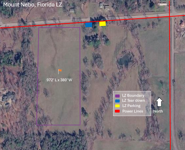
| Launch altitude ft | 1,740 |
|---|---|
| LZ altitude ft | 463 |
| Launch to LZ distance | 1.5 mi |
| Glide ratio to LZ | 6.2 |
Notes – Florida LZ (PG only)
The Florida LZ is adjacent to the home of a long time pilot whose house is located on the northeast corner of the LZ. Parking can be arranged in his yard with easy walking access to the East LZ. There is a power line bordering the north side of the field. Tall trees on the south end require the pilot to work off altitude before entering the field. This field is also used as a horse pasture and caution should be used if they are present.
PG
[none]
HG
[none]
[we need photos of Vernon LZ - please contact Britton Shaw if you can supply - thank you]
Ware LZ
35.2380 -93.2430 Dardanelle, Arkansas
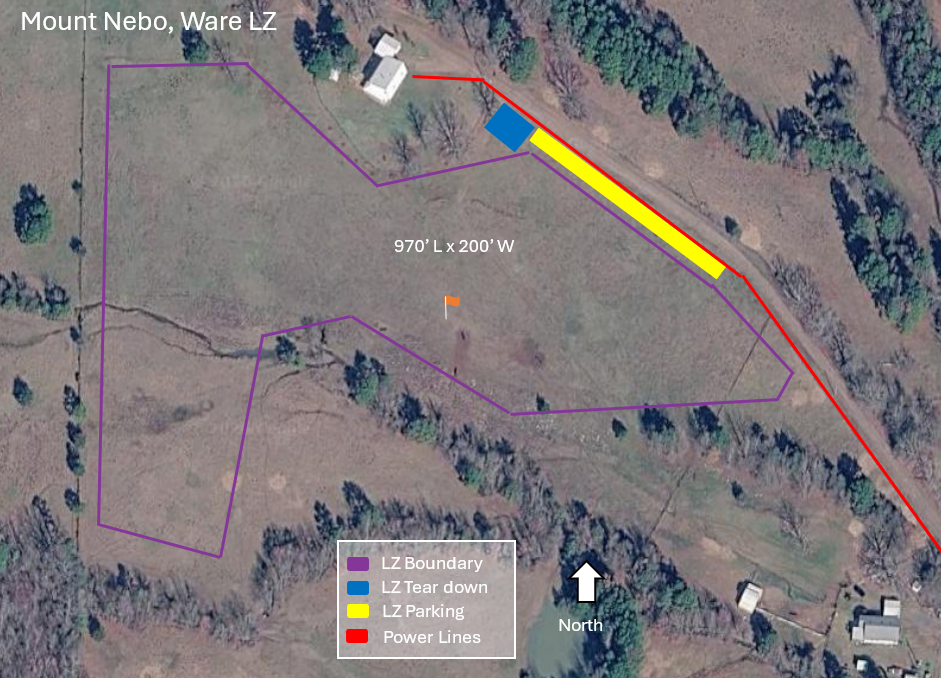
| Launch altitude ft | 1,703 |
|---|---|
| LZ altitude ft | 513 |
| Launch to LZ distance | 1.0 mi |
| Glide ratio to LZ | 4.4 |
Notes – Ware LZ
The access road dead ends at the Ware residence. Vehicles and spectators are not allowed in the landing field. Vehicles should park on the side of the lane before arriving at the residence. Visiting pilots are expected to visit the Ware and Wesley landing zones before using the northeast launch.
A north final approach for the Ware LZ requires crossing a small creek (running primarily northwest to southeast) to an uphill slope toward the residence. The base leg for this approach should be made just above the trees on the south side of the field. Northwest or southeast final approaches can be made on the slope.
PG
[none]
HG
[none]
[we need photos of Ware LZ - please contact Britton Shaw if you can supply - thank you]
Wesley LZ
35.2335 -93.2256 Dardanelle, Arkansas
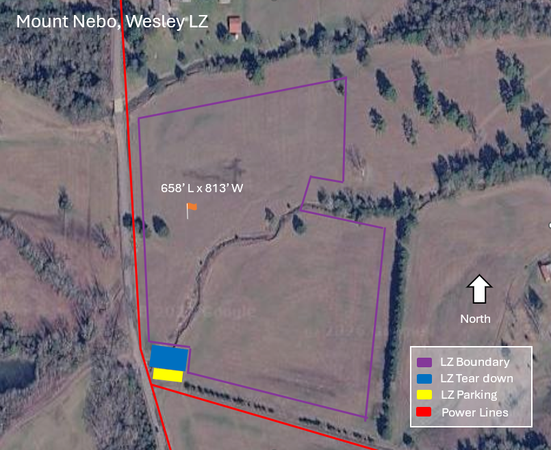
| Launch altitude ft | 1,703 |
|---|---|
| LZ altitude ft | 416 |
| Launch to LZ distance | 1.8 mi |
| Glide ratio to LZ | 7.4 |
Notes – Wesley LZ
[none]PG
[none]
HG
The Wesley LZ is used primarily for pilots when attempting cross country flying and is a more desirable LZ than the Ware LZ when launching from the Nebo Northeast launch. There is a significant hazard with the creek running through the middle of the field when using a north or south final approach. The field is used primarily for hay production and the grass can be waist high or filled with hay bales during the summer growing season. Please give the field a visual look before planning to land here.
[we need photos of the Wesley LZ - please contact Britton Shaw if you can supply - thank you]