
Heavener
Revision Date : January 30, 2026
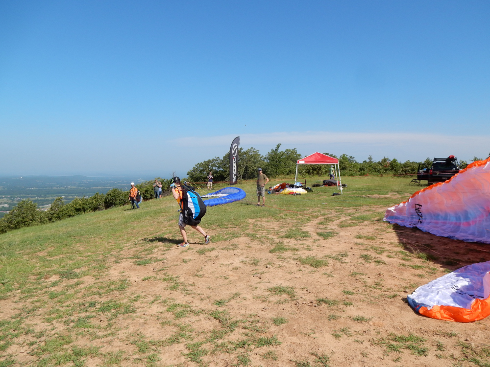
Launch
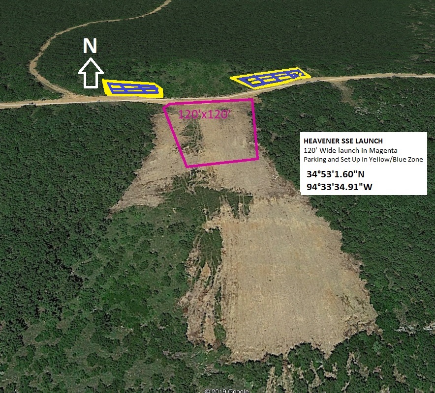
Launch & LZ info: Southwest & South Southeast
South Southeast launch CLOSED per request of landowner
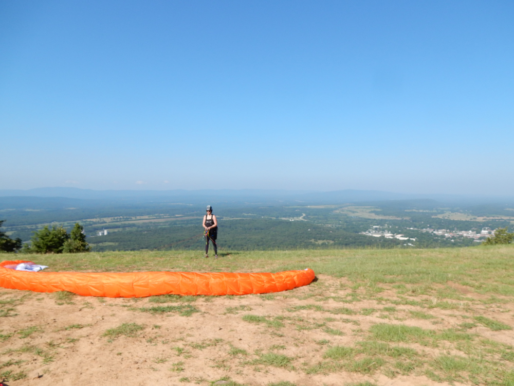
Audra Gately ready to go!
Notes – general
Best known for a cryptic stone found outside the city, Heavener was home to the 1977 National Hang Gliding Meet. The stone is located in the Heavener Runestone Park and is believed to have its origins from the early Vikings who traveled to this area. The Heavener flying sites were developed early in the 70's by Bruce & Roy Mahoney and other hang gliding pilots. We are very thankful for the fruits of their difficult and tireless work to make them available to the ultralight community.
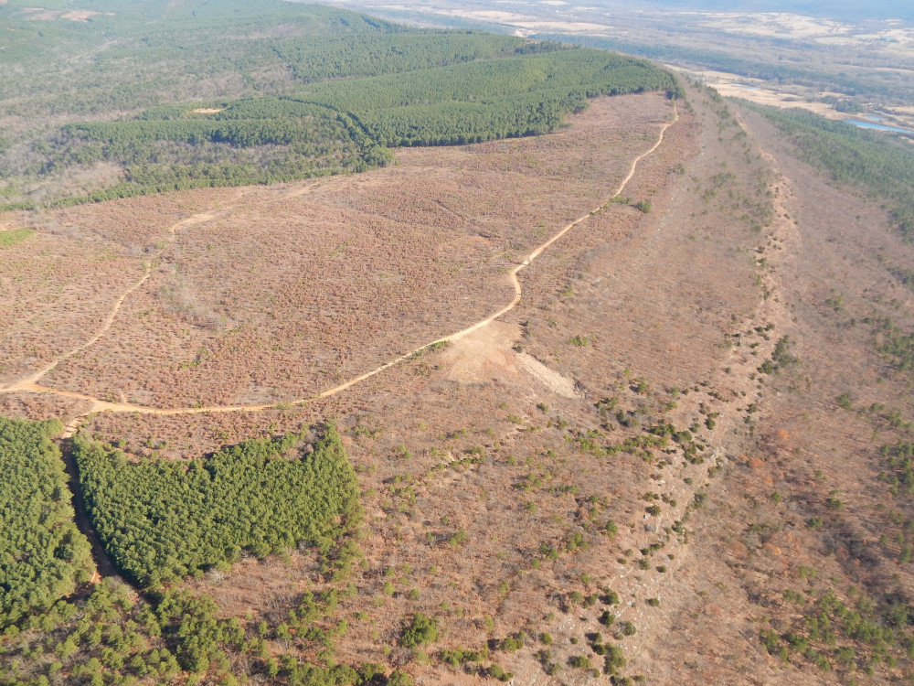
Heavener has two grassy slope launches which are located on private land (non-tribal) that is along the ridge above Heavener and face primarily SW and SSE.
Visitors will need to contact the site coordinator, Britton Shaw, for detailed information on accessing this site. Hang gliding and paragliding pilots must pass through the park when traveling to launch. Following the speed limit signs through the park is imperative! A steep ascent over a jutting rock formation must be made after leaving the park. Before and after reaching the second gate a significant patch of clay must be crossed. In or after rainy weather a 4 wheel drive vehicle may be required to get to the launches. Both launches offer thermal flying and ridge soaring opportunities. The southwest launch is positioned on a mile long ridge and the south facing ridge extends 5 miles east of the launch.
If there are plans to have anything or anyone present at the launch areas after dark, notify the Park Manger: Amanda Garcia (918) 983-2013. The Park closes at dark and you will not be able to get in or out.
All pilots must read these additional requirements for Heavener.
P2 pilots:
- Before flying Heavener for the first time, receive clearance for flight at that site by an USHPA instructor who is experienced flying the site.
- The first 5 flights at each site must be made with guidance by a P3 or better pilot who is experienced flying the site.
- Once OK'd, all subsequent flights must be made with guidance by a P3 or better pilot who is experienced flying the site.
H2 Pilots:
- H2 pilots are not allowed to fly Heavener.
P2 pilots - additional limitations for novice pilots:
- Should fly only in smooth winds of 8 mph or less and gusty winds to 5 mph.
- If foot launching, should launch only on slopes 2:1 to 7:1, where wind is within 25° of being straight up the slope.
- Should maintain heading within 90° of directly into wind, and within 45° of directly into wind below 60' AGL.
- Flight speed: Should not attempt to fly slowly when encountering lift but, instead, concentrate on maintaining attitude, heading, and airspeed. Slow flight might result in a stall, which could be hazardous within 500’ of any object.
- Fly only in stable conditions such as morning, evening, or overcast days.
P3, P4, & P5 pilots:
- Before flying Heavener for the first time, receive site orientation by a P3 or better pilot experienced flying the site.
H3, H4, & H5 pilots:
- Before flying Heavener for the first time, receive site orientation by a H3 or better pilot experienced flying the site.
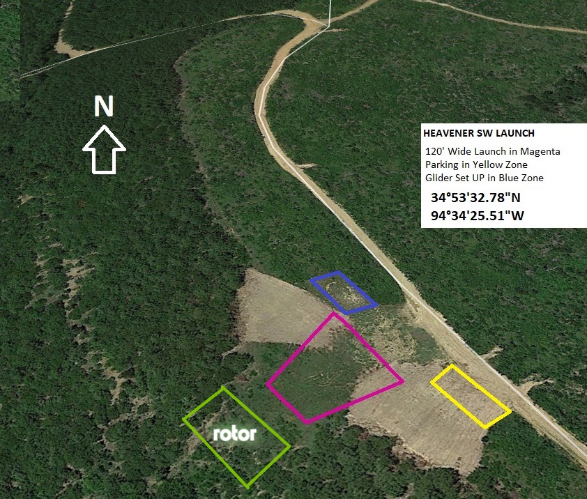
Southwest launch
34.8923 -94.5738 Heavener, Oklahoma
Requirements for pilots
| PG minimum required rating & special skills | P2 | P3 FL CL | |
|---|---|---|---|
| Recommended wind limits (mph) | Min:0 | Min:0 | |
| Ideal:7 | Ideal:7 | ||
| Max:12 | Max:15 | ||
| 5 mph max differential in 5 seconds | Peak:15 | Peak:18 | |
| Wind direction ideal for PG | 225° | ||
| Wind direction OK for PG | 190°-270° |
| HG minimum required rating & special skills | H2 FL RLF | H3 FL RLF | |
|---|---|---|---|
| Recommended wind limits (mph) | Min:5 | Min:5 | |
| H2 gusty winds to 11 mph | Ideal:12 | Ideal:12 | |
| H2 wind dir <25° straight up slope | Max:18 | Max:20 | |
| H3 gust differential 10 mph or less | |||
| Wind direction ideal for PG & HG | 225° | ||
| Wind direction OK for PG & HR | 190°-270° |
| Launch altitude ft | 1,402 |
|---|---|
| LZ altitude ft | 609 |
| Launch to LZ distance | 0.7 mi |
| Glide ratio to LZ | 4.7 |
Notes – Southwest launch
- There is no shade at launch. Be prepared! Summer days can be very hot.
- Easy glide to the LZ from launch.
- During higher winds, mild turbulence can be encountered when approaching the headwall. Areas of sink may be encountered, but
this has little impact on making the LZ.
- LZ contains a few stray trees, but overall area is vastly open for an easy approach to land.
- Natural weather conditions pose the greatest hazard: 1. Spring and Summer pop up thunderstorms 2. Summertime evening winds can ramp up rapidly 3. Katabatic Winds late in the evening are possible.
PG
Launching when wind is crossing at a stronger velocity from the northwest, rotor is created at the headwall. It is not uncommon for pilots to fail to reach the headwall and be forced down into the trees.
HG
This launch offers the best roll-off launch BMF has to offer. When launching in stronger winds it is recommended that HG pilots move further down the hill as two to four steps may be all that is required to get airborne.
Southwest launch
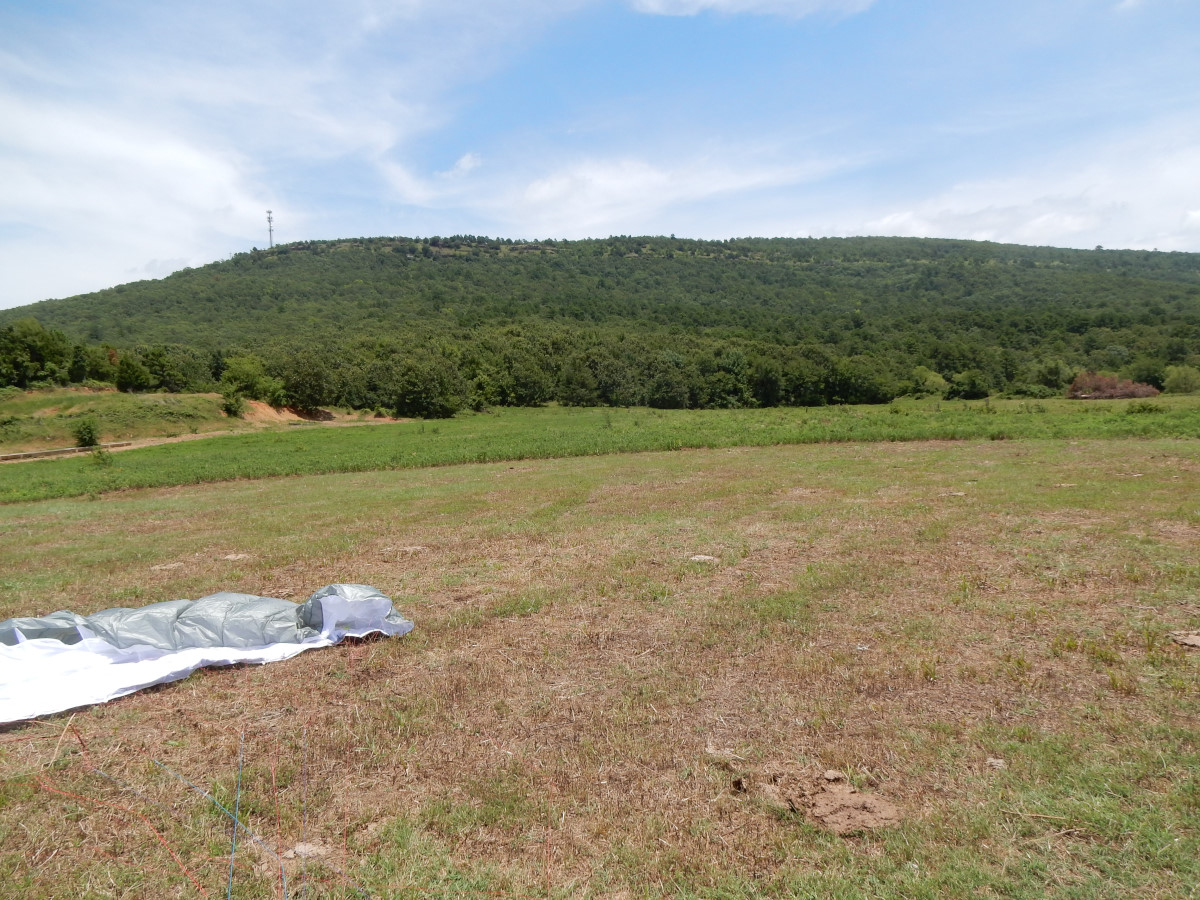
Southwest LZ
34.8901 -94.5857 Heavener, Oklahoma
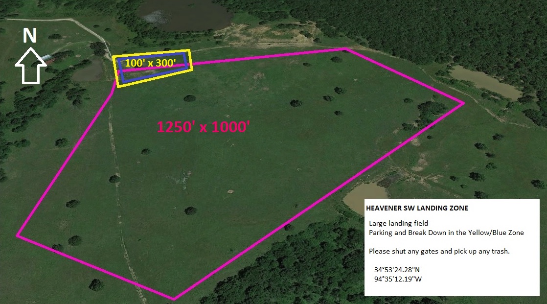
Notes – Southwest LZ
Visitors will need to contact the site coordinator, Britton Shaw, for detailed information on accessing the LZ which is on private property behind a locked gate.
PG
Pilots need to be on the lookout for cows and manure pies in the LZ when setting up to land. Remember: it is better to hit a pie square than spin your paraglider 20' from the ground. Many pilots have been seriously injured avoiding obstacles in the LZ that, otherwise, might have resulted in a minor bruise or cut.
HG
The Southwest LZ is a cattle pasture as mentioned above. Cattle are not the only obstacle one may encounter when entering the field. Tall grass may be present, scattered trees, and a barb wire fence traversing the western boundary of the field. Newer pilots making a southwest final will need to lower their altitude to just above the trees on the northeast corner of the field.
Southwest LZ
South Southeast launch CLOSED
34.8838 -94.5597 Heavener, OK